Algeria
 Egypt
 Libya
 Morocco
 Sudan
 Tunisia
 Benin
 Burkina Faso
 Cabo Verde
 Côte d'Ivoire
 Ghana
 Guinea
 Guinea-Bissau
 Liberia
 Mali
 Mauritania
 Niger
 Senegal
 Sierra Leone
 The Gambia
 Togo
 Cameroon
 Central African Republic
 Chad
 DR Congo
 Equatorial Guinea
 Gabon
 Republic of the Congo
 São Tomé and Príncipe
 Burundi
 Comoros
 Djibouti
 Eritrea
 Ethiopia
 Kenya
 Madagascar
 Malawi
 Mauritius
 Mozambique
 Rwanda
 Seychelles
 Somalia
 South Sudan
 Tanzania
 Uganda
 Angola
 Botswana
 Eswatini
 Lesotho
 Namibia
 South Africa
 Zambia
 Zimbabwe
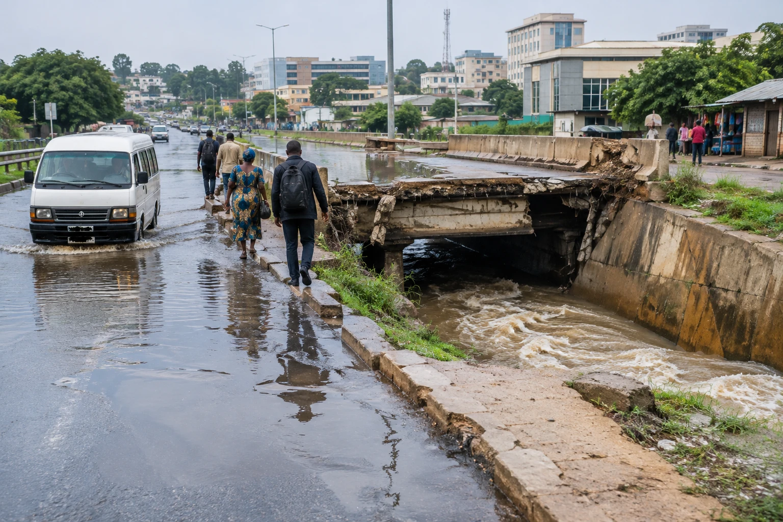
In Gudu, in southern Abuja, a road weakened by rain is a reminder that urban flooding does not necessarily begin on the banks of a major river. When a bridge deteriorates, water floods the road and drains overflow, everyday journeys become a risk for residents, workers and small businesses alike.
The problem extends beyond one neighbourhood. It raises questions about how Nigeria’s federal capital has developed around a master plan drawn up in 1979, and whether the authorities can enforce the protection of areas set aside for water to flow. Observations gathered on the ground point to a gap between the planned urban regulations and construction that has gradually spread into sensitive areas.
A planned capital exposed by its development
Abuja was not conceived as an improvised city. Its master plan, completed in 1979, was intended to organise urban expansion and take the characteristics of the terrain into account. The Federal Capital Territory Administration (FCTA) says the plan is now being revised. The Japan International Cooperation Agency also describes an update project intended to guide the development and transport of a growing capital. Information from the FCTA on Abuja’s master plan and the update project supported by JICA confirm that this revision is a major institutional issue.
Planning alone cannot prevent floods. It protects the city only if drainage channels remain clear, permits comply with the constraints of the terrain, and infrastructure keeps pace with urban expansion. When buildings occupy areas where water flows or green spaces recede, there is less ground for rain to soak into. Water then reaches streets and low-lying areas more quickly.
Nigerian authorities had flagged the risk before the rainy season discussed in the report. In May 2024, the National Emergency Management Agency (NEMA) took part in an assessment of vulnerable locations in the Federal Capital Territory, including Dogon-gada, EFAB Lokogoma and the Galadimawa area. The annual forecast from the national hydrological agency, NIHSA, also listed Abuja among the cities at risk of flash floods and urban flooding. NEMA documented this preventive assessment; the federal government presented NIHSA’s 2024 forecasts.
Local damage, shared responsibilities
In Gudu, a resident, Danjuma Silas, describes a road that has been deteriorating for several years when heavy rain falls. He says the water makes the bridge difficult to see and that people have fallen into the watercourse. His account highlights an immediate danger, but cannot on its own confirm a death toll. No casualty figures are given here without independent verification.
Nathaniel Atebije, a former head of the Nigerian Institute of Town Planners, attributes part of the problem to land-use decisions, particularly in ecologically sensitive areas. This analysis touches on the responsibilities of the FCTA and the Federal Capital Development Authority (FCDA), which oversee development, land allocation and urban controls in the federal territory. For residents, the consequences are tangible: disrupted journeys, more difficult access to services and potential damage to homes or businesses.
Federal Capital Territory Minister Nyesom Wike has argued that some building permits were issued before he took office. He has also ordered the demolition of buildings encroaching on waterways. Demolition can clear routes for water, but it cannot replace the repair of drains or consistent enforcement of permit rules. It also raises a social question: those affected need clear rules, information about decisions and fair procedures.
Paul Gwumapan Joseph, advocacy lead at the Nigerian NGO network CSDevNet, points to another factor: waste management. Rubbish blocking drains can slow water flow and worsen overflow. Responsibility does not rest solely with households. It also depends on municipal collection, regular maintenance of networks and the ability of public services to act before the heaviest rains.
Risk is not distributed equally. A blocked main road penalises those who depend on transport to get to work or school. Vendors and small businesses can lose hours of trading, while neighbourhoods with better-maintained roads may find it easier to get around flooded areas. The damage therefore affects mobility and income, as well as buildings directly inundated.
The new plan must turn warnings into decisions
The FCTA says the 1979 plan is being revised. At the same time, the update project described by JICA aims to provide a framework for the capital’s development. The challenge will be to translate the revision into enforceable measures: mapping flood-prone areas, protecting natural drainage channels, adapting networks to urbanisation and maintaining infrastructure. Publishing the plan will not be enough if permits and construction work fail to comply with it.
The rainy season also makes coordination between forecasts, warnings and local responses essential. NIHSA data and NEMA assessments will have an impact only if municipalities and Territory services can turn them into inspections, drain clearance, information for residents and the securing of dangerous crossings. Moving from warning to action can reduce damage before it occurs.
Across West Africa, Abuja faces challenges familiar to other expanding cities: pressure on land, undersized drainage networks and intense rainfall. ECOWAS, the regional organisation of West African states, has called on its members to integrate disaster risk reduction and climate action into urban planning. It also recommends better sharing of data and forecasts between countries. ECOWAS’s regional recommendations on disaster management therefore place the issue in Abuja within a prevention effort that extends beyond Nigeria.
For residents of Gudu, the test is the condition of the bridge and whether they can travel safely during the next rains. For the authorities, it will be their ability to enforce protected zones, maintain drains and make the new master plan work on the ground. The capital already has warnings and competent institutions; the challenge is to link them to lasting decisions.